


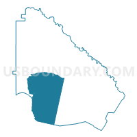
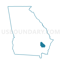
3052A - SCREVEN Voting District, Wayne County, Georgia
About
Outline

Summary
| Unique Area Identifier | 563096 |
| Name | 3052A - SCREVEN Voting District |
| County | Wayne County |
| State | Georgia |
| Area (square miles) | 108.04 |
| Land Area (square miles) | 107.62 |
| Water Area (square miles) | 0.43 |
| % of Land Area | 99.60 |
| % of Water Area | 0.40 |
| Latitude of the Internal Point | 31.46557340 |
| Longtitude of the Internal Point | -81.97379030 |
Maps

Graphs
Select a template below for downloading or customizing gragh for 3052A - SCREVEN Voting District, Wayne County, Georgia


Neighbors
Neighoring Voting District (by Name) Neighboring Voting District on the Map
- 0254 - HORTENSE Voting District, Brantley County, GA
- 2294A - PATTERSON Voting District, Pierce County, GA
- 3052B - RITCH Voting District, Wayne County, GA
- 3052C - EMPIRE Voting District, Wayne County, GA
- 3053B - GARDI Voting District, Wayne County, GA
- 3055B - REC CENTER Voting District, Wayne County, GA
- 3055C - EAST JESUP Voting District, Wayne County, GA
Top 10 Neighboring County Subdivision (by Population) Neighboring County Subdivision on the Map
- Jesup CCD, Wayne County, GA (22,247)
- Nahunta CCD, Brantley County, GA (6,224)
- Screven CCD, Wayne County, GA (3,448)
- Patterson CCD, Pierce County, GA (2,902)
Top 10 Neighboring Place (by Population) Neighboring Place on the Map
Top 10 Neighboring Unified School District (by Population) Neighboring Unified School District on the Map
- Wayne County School District, GA (30,099)
- Pierce County School District, GA (18,758)
- Brantley County School District, GA (18,411)
Top 10 Neighboring State Legislative District Lower Chamber (by Population) Neighboring State Legislative District Lower Chamber on the Map
Top 10 Neighboring State Legislative District Upper Chamber (by Population) Neighboring State Legislative District Upper Chamber on the Map
- State Senate District 3, GA (175,054)
- State Senate District 7, GA (162,770)
- State Senate District 19, GA (161,882)
Top 10 Neighboring 111th Congressional District (by Population) Neighboring 111th Congressional District on the Map
Top 10 Neighboring Census Tract (by Population) Neighboring Census Tract on the Map
- Census Tract 9602, Brantley County, GA (6,224)
- Census Tract 9705, Wayne County, GA (5,426)
- Census Tract 9703, Wayne County, GA (4,917)
- Census Tract 9706, Wayne County, GA (3,555)
- Census Tract 9704, Wayne County, GA (3,448)
- Census Tract 9601, Pierce County, GA (2,902)